 An image of the Matrimandir temple in Auroville, India taken by Satellogic’s NewSat-30 high-resolution EO satellite, March 30, 2023. (Source: Satellogic)
ALEXANDRIA, Va. — Democratizing access to Earth observation (EO) data is critical to a growing number of governments and industries that rely on actionable insights on climate change, global conflict and other events.
Organizations like Satellogic—a 14-year-old satellite data provider—are helping a growing number of stakeholders get closer than ever to having near-constant visibility of Earth’s landmass in super-close detail, down to tens of centimeters.
“We aim to get to a point where we would be doing daily world remaps of the whole globe in high resolution,” said Luciano Giesso, Vice President of Space Systems at Satellogic, noting that the company has launched 48 satellites to date. “That’s our ultimate goal. And for that, we think we will need somewhere a little above 200 satellites, and we’re on the road to get to that point.”
In April, Satellogic received a $30 million strategic investment from cryptocurrency company Tether Investments Limited, following the news that it would relocate operations to the U.S. to compete for government contracts.
The investment, just one of many in EO satellite companies over the last 12 months, is a testament to the immense potential for data derived by satellites in low Earth orbit (LEO): The Earth observation market was valued at $4.6 billion in 2022, according to Euroconsult. The EO service market and business-to-government sector are expected to drive growth over the next decade with compound annual growth rates (CAGR) of 6% and 4% respectively.
“Environmental needs, national security needs, commercial needs—all three are going up,” says Aravind Ravichandran, an EO consultant and the founder of TerraWatch Space. “The national security need is the one that is a lot more ... validated. The government needs from an environmental point of view are coming up, as you need to monitor disasters, agriculture, forestry and so forth.”
Yet while advances in optical networking, satellite capacity and onboard computing have demonstrated the awesome potential of EO satellites in 2024, factors such as industry competition, pricing and commercial use-case viability are top of mind.
Emerging EO Satellite Applications for Government
The onset of the Ukraine-Russia conflict in February 2022 made clear to the global public how helpful observation satellites are in monitoring changes of interest. As a paper published in the journal Nature observed, satellites provided “timely insights” into the impacts of the ongoing war on Ukrainian society, including environmental damages and risks to energy and industrial infrastructure, urban areas, agricultural and natural resources.
For military and intelligence end users, satellite-based imagery has been crucial in helping monitor borders and hotspots, said Giesso, for example, in relation to the ongoing conflict in Ukraine.
“We provide imagery to monitor their borders and areas where they’ve been invaded or they’re about to be invaded and look for natural resources or places where the civil population may more safely evacuate,” said Giesso, referring to Satellogic’s support to Ukraine, NATO and the U.S. “Those are actual uses that have been implemented with our imagery.”
Giesso said that the observation satellites’ high frequency of revisit—delivering high-quality images within 3-6 hours of capturing them—can make a huge difference in time-sensitive operations.
“When it comes to defense and intelligence clients, timing is everything,” said Giesso. “Typically, we can do daily or better revisits to any point of interest on Earth. And that’s the kind of approach that we have whenever we are requested imagery or services from any defense and intelligence clients.”
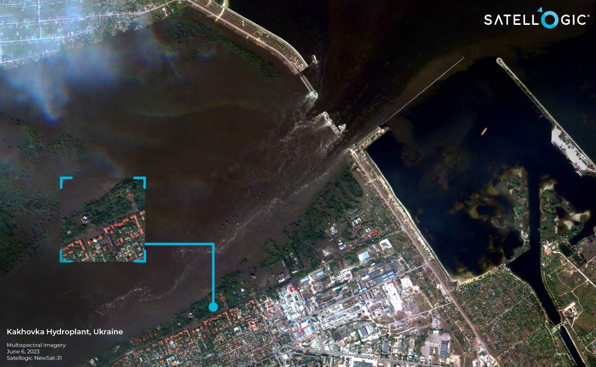 An image of the destroyed Kakhovka Hydroelectric Power Plant in the Russian-controlled Kherson region of Ukraine taken by Satellogic’s NewSat-31, June 6, 2023. (Source: Satellogic)
But it’s not just demands for defense enhancement that’s driving new business. Outside of defense and intelligence, advances in EO satellite data processing have fueled environmental and maritime monitoring, as well as space situational awareness.
Giesso offered the example of Satellogic’s recent work with the Republic of Albania and Brazil as successful cases in improving environmental monitoring and raising awareness of concerns.
“They use a portion of our satellite fleet while the satellites are orbiting above Albania with exclusive rights of every image that they capture,” said Giesso. “We monitored wildfires and we’re doing a bit of monitoring on conservation and environmental programs for them.
Looking at other civil applications, such as in Brazil, Satellogic has been tapped to monitor agricultural and forestry areas.
“A nice program that we have collaborated on has to do with the Amazon reforestation program,” said Giesso. “So, we had been procuring different areas to look at illegal tree removal and other related activities.”
Capacity, Technology … and Pricing
While technology, such as onboard processing, continues to evolve, and satellite capacity expands, EO providers feel the pressure to elevate their offerings.
“When it comes to what’s really needed and what we see the market is very much pursuant of, it is capacity to reduce latency,” said Giesso. “Our clients and customers in the governmental sector especially, they require faster and faster turnaround times in terms of getting the data. So, in line with that, we need to launch more satellites.”
In 2023, Satellogic launched 12 satellites. It has launched two satellites so far in 2024, with many more planned for 2025.
“The idea is with more and more satellites, we can get better coverage and we can get better latency,” said Giesso. “We’re looking at enhancing our sensor, on the optical side. We have a roadmap straight ahead to go down to 30-centimeter resolution imagery in our sensors. But we also see that capacity matters a lot. So, I would say that that is the main point to address the market’s demand.”
Giesso said that Satellogic is also looking to expand access to EO technology globally through a tiered pricing approach.
In November Satellogic announced a partnership with India’s Tata Advanced Systems Limited, a defense and aerospace company, to establish and develop local space technology capabilities in India. This collaboration was described as a first step in TASL’s satellite strategy and a significant milestone for Satellogic – which hoped to accelerate space capacity building for one of the largest nations in the world.
“Many countries never launched a satellite or don’t have any kind of capacity,” said Giesso, saying that Satellogic’s tiered offerings (including satellite ownership options for $10 million or less) make space significantly more accessible for governments around the world.
In turn, Satellogic hopes that tiered solutions at multiple price points can help non-government organizations—such as its NGSO partner is SkyFi—benefit from the power of satellite data.
However, increasing competition among satellite providers could drive prices downward, while concerns over the value of EO satellite data could impact growth in commercial markets, Ravichandran cautions.
“Just the fact that you have a lot of supply is bringing prices down, because a lot of the needs [for EO] are not validated,” said Ravichandran. “I think the only kind of customer who pays a premium and is okay paying a premium is the government and it’s because the government knows how to use the data, whether it’s [for] reconnaissance, whether it’s surveillance, or whether it’s using the data on the battlefield. They need the data. On the commercial side ... because they’re still figuring out what this data is really useful for, you can’t really increase the price for them. I think that’s kind of what a lot of companies are trying to navigate.”
Explore More:
Podcast: Satellite-as-a-Service, Data Fusion and Sovereign Earth Observation
European Commission Takes First Step Toward Military-Civil EO Service
The Implications of Increasing Earth Observation Data
The Complicated History of US Commercial SAR