
The conflict in Ukraine has publicized several innovations in warfare, most notably the use of small drones and the military utility of Commercially Available Information (CAI). The widespread use of commercial overhead imagery has been widely reported but less attention has been given to commercial monitoring of satellite signals and the insights they reveal about on-the-ground activities.
Predictive Satellite Signal Monitoring
The impact of this technology can be seen by watching areas of conflict like Russia and Ukraine. For example, in late 2021, the military build-up along the Ukrainian border was not only visible in overhead imagery but also in satellite spectrum utilization. Activated military units increased satellite communications signals as they prepared to move west causing a more than three-fold spike in signal activity on the communications satellite Yamal 401.
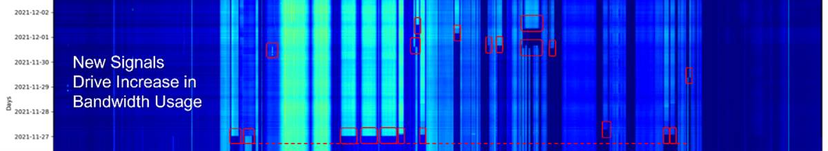 Figure 1: Increased satellite spectrum utilization of the Yamal 401 satellite (Source: Kratos Global RF Sensor Network Operations)
Electromagnetic attacks against communications signals can foreshadow a kinetic assault on the ground. For instance, Figure 2 is a waterfall plot showing intentional interference disrupting communications on Yamal 401. Jamming against Russian military communications were observed in the month before the 2023 Ukranian summer counter-offensive. Jamming techniques can reveal information about the objectives of the operator. This particular jammer was using a Stepped-Frequency Continuous-Wave Signal (SFCW) that is difficult to detect or attribute and is well-suited to jammers located in vulnerable positions. It is interesting to note that jammers operating from safety often use matched waveform jamming which is powerful but easier to detect.
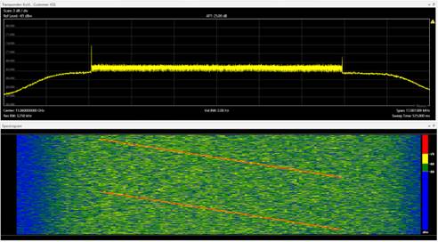 Figure 2: SFCW signal reveals deliberate interference targeting communications on Yamal 401 (Source: Kratos Global RF Sensor Network Operations)
Discovering the Location of Transmitters on the Ground
Changes in satellite communication signals can predict impending activity on Earth and it is possible to discover even more by examining the location of the ground-based transmitters utilizing satellite communications.
There are two primary ways to use communication satellites to geolocate an RF emitter. The first is a “Self-Reported Geolocation.” Some transmitters encode their own location in the communications protocol. It is possible to extract the Self-Reported Geolocations and map the transmitters by using an antenna on the ground to observe the satellite traffic.
The second technique to locate an emitter is known as “Two-Ball Geolocation” and requires two satellites that observe and rebroadcast the signal sent by the ground-based transmitter. Two ground-based antennas collect the rebroadcasted signal, compare the difference of arrival and compute the ground-based location of the transmitter.
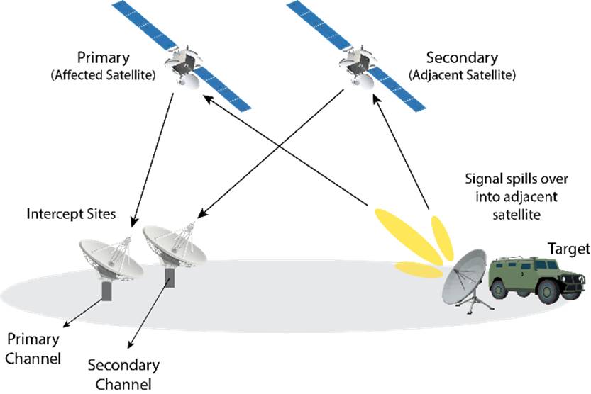 Figure 3: Two-Ball Geolocation technique used to locate emitter.
Interesting results were discovered by comparing the Two-Ball Geolocation to Self-Reported Location. In most cases, these two different techniques produced the same answer, but not always. Two signals on Express AM8 Self-Reported their location as the InSat Ground Station in Saarbrücken, Germany and overhead imagery even showed an antenna pointed at Express AM8. However, InSat was liquidated in 2020 and a service provider named Hi-Stream acquired the assets.
The Two-Ball Geolocation revealed the transmitters were in Pereslavl-Zalesskiy, Russia.
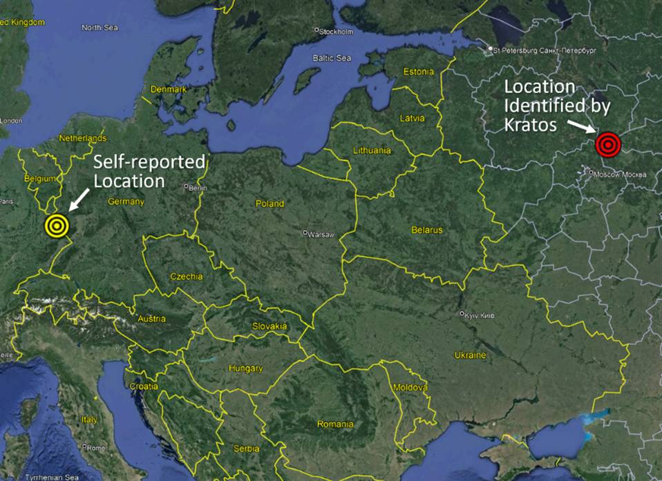 Figure 4: Carriers on Express AM8 reported their location in Saarbrücken, Germany while the signals originated from a different location. (Source: Google Earth and data extrapolated from Kratos Global RF Sensor Network Operations)
When a transmitter’s Self-Reported location is wrong, it can indicate the user is attempting covert or misleading actions. In this case, it was more likely a simple oversight. When the equipment in Saarbrücken was moved, the terminal’s location was never updated and so the satellite signals revealed not only where the transmitters were currently located, but where they came from.
Who is depending on Express AM8?
Examining satellite signals can yield insight into economic and political realities on the ground. More than 3,000 terminals in France, Portugal, Poland and Italy were paying the Russian Satellite Communications Company (RSCC) for bandwidth on Express AM8.
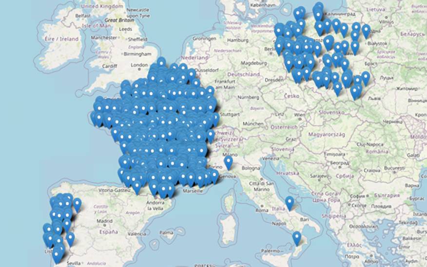 Figure 5: Location of European terminals that were using bandwidth on Express AM8 (Source: Google Earth and data extrapolated from Kratos Global RF Sensor Network Operations)
Correlating observations on multiple networks revealed even more insights. On Express AM8 there were seven unique TDMA networks all using identically configured modems. Geolocation of the hub signals for each of these networks pointed to a complex south of Moscow. Open sources had very little to say about this facility and Google Maps labeled it as a research foundation called Zona 52. A declassified CIA report from 1971 described it as a major transmitting and direction-finding facility, though key details about the site’s purpose are still classified. Overhead imagery of the complex showed multiple antenna fields. The central control building hosted a large parabolic antenna on the roof pointed directly at Express AM8.
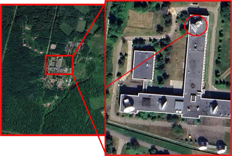 Figure 6: Satellite signals geolocated to Podolsk/Romantsevo Communications Complex with likely transmit antenna based on pointing angle (Source: Google Earth and Kratos Global RF Sensor Network Operations)
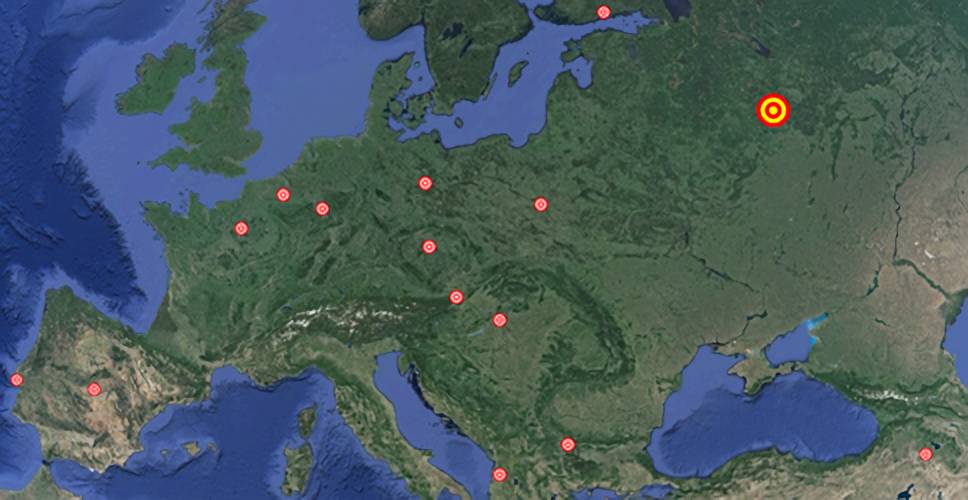 Figure 7: The communications complex in Russia was a hub for remote terminals in European cities such as Brussels, Berlin, Paris and others. (Source: Google Earth and data extrapolated from Kratos Global RF Sensor Network Operations)
Of note, the signal geolocations for each of the remote sites were near a foreign embassy or consulate. Overhead imagery of these buildings showed parabolic antennas pointed at Express AM8.
It is easy to assume that only space professionals are interested in monitoring satellites, but the reality is that satellite signals reveal a wealth of information about what is happening on the ground. When it comes to predicting military movements, discovering who is reliant upon a satellite, or finding ground-based transmitters, answers about space age conflict can be learned by watching signals.
About the Author
Hugh White is Senior Director of Space Domain Awareness Services for Kratos Federal Space. Hugh defines the vision, business strategy and capability offering for the Kratos Global RF Sensor Network through innovative, high-fidelity, radio frequency-based Space Domain Awareness solutions for government, commercial and international partners.
Explore more:
Tracking Interference: The Ukrainian Battlefield Reaches into Space
Podcast: Threat Tracking, Information Sharing and the Watch Center
Espionage in Orbit: Satellite or Spy?
University Spotlight: How an Experimental GPS Receiver is Changing Electronic Warfare